GEOPHYSICAL HAZARDS
Overview
Geophysical hazards stem from inherent geophysical processes within the Earth, encompassing phenomena such as tectonic activity, volcanic eruptions, and seismic events. These processes give rise to catastrophic events, including but not limited to earthquakes, volcanic eruptions, landslides, and sinkholes, among others. The occurrence of these hazards possesses the potential to cause substantial adverse ramifications upon human populations, infrastructure, and the environment.
It is important to note that while these events are classified as geophysical disasters, they are often interconnected with other natural and human-induced factors. Consequently, these geophysical hazards don’t always occur in isolation; they can intertwine with one another or with other factors caused by humans. This interaction can lead to a situation where these hazards happen alone or in conjunction with other hazards, making the overall effects they produce more substantial. This pertains not only to how extensive the impact is spread but also to the scale of the effects, how intense they are, and how long they persist. In essence, these hazards can become more formidable when they join forces with other factors, magnifying the challenges they pose.
Geophysical Disasters
Earthquakes
As per the definition provided by the United States Geological Survey (USGS), an earthquake is characterised as a sudden slip along a fault line, leading to ground shaking and the release of seismic energy (USGS, no date). The measurement of earthquakes is typically conducted using the Richter scale. The most significant magnitude registered within the last decade was recorded in Orkney City (North West Province) on the 14th of August 2014, specifically 5.4 magnitudes, as reported by https://earthquakelist.org/and confirmed by EM-Dat data accessible through https://public.emdat.be/
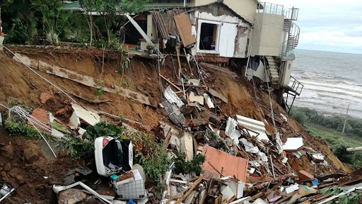
Landslides/Mudslide
Landslides are the downslope displacement of various materials, such as soil, rock, and organic substances, driven by the gravitational forces when they surpass the frictional resistance of the material resisting the slope (Varnes, 1978). In South Africa, mudslides and landslides frequently occur as a result of heavy rainfall and flooding events. Therefore, subsequent to the extensive flooding experienced in the KwaZulu-Natal Province in April 2022, NASA meticulously and manually mapped the locations of 91 landslides that occurred as a result of the flooding in KwaZulu-Natal (NASA, 2022).
Volcanic Activity
A volcano is formally defined as a rupture in the Earth’s crust through which hot lava, volcanic ash, and gases are emitted (). The process by which these materials are expelled from the Earth’s interior is referred to as a volcanic eruption, which can vary in terms of intensity (). It is important to note that there are no documented records of volcanic activity within the geographical boundaries of South Africa. However, on the 4th of June 2011, a significant event occurred when a cloud of volcanic ash resulting from an eruption in the Andes region remained suspended over the Cape Town area for an extended period, persisting for approximately nine days (SAWS, 2017).
Earthquakes in South Africa
On the 11th of June 2023, an earth tremor with a magnitude of 4.9 was recorded in Alberton, which is located to the south of Johannesburg. This seismic event was followed by additional tremors within the Gauteng province, occurring on June 27th and July 22nd, both registering a magnitude of 4.2 on the Richter scale.
Within the geographical context of South Africa, occurrences of landslides, mudslides, and volcanic activities are relatively rare. Therefore, the primary focus of the geophysical hazards in this communication is centered on the occurrences of earthquakes. Two distinct sources have been identified as valuable repositories of seismic data for South Africa. A brief overview of the information and data obtained from these sources is presented below for your reference.
Data Sources
Additional information pertaining to the likelihood of the occurence of fires occurrences of geophysical hazards, specifically earthquakes, can further be investigated and explored through the links and sites listed below.
| Data Source | Link | Supplementary Information |
|---|---|---|
|
EM-Dat |
Occurrence of natural disasters which either impacted at least 100 people, caused the death of at least 10 people, an official state of disaster was declared or an appeal for international humanitarian assistance was made. |
|
|
Earthquake List |
This database provides an overview of the latest earthquakes in South Africa. This database is updated every minute and includes all seismic activity (minor and major) reported and recorded in South Africa. |