Coastal Risk & Vulnerability

This research blog is aimed at describing the nature of coastal risks and vulnerability in South Africa, highlighting the commonly experienced threats that leave coastal communities, infrastructure and ecosystems more susceptible to hazardous events.

Contents

Share this resource:

Last updated: November 2023 | Authors:Keneilwe Hlahane

Coastal Risk & Vulnerability

South Africa (SA) has a coastline that is 2 798 km long and covers a surface area of 1 219 602 km². The country’s coastline is bordered by the Atlantic Ocean on the west and the Indian Ocean on the East. SA’s coastline is divided into three main biogeographic boundaries: the cool-temperate west coast, the warm-temperate south coast, and the subtropical east coast (Teske et al.2006). South African low-lying coastal areas have been exposed to risk and vulnerability (like other coastal areas around the world) due to threats such as global warming, climate change (e.g., sea-level rise, increased water discharge, floods), and other forms of environmental degradation, i.e., erosion and flooding along the coastline. Coastal vulnerability in SA has had a negative impact on ecosystems and people. These include, but are not limited to health-related effects, and socio-economic impacts (Kabisch et al. 2017).

Coastal risk and vulnerability refer to the degree to which coastal areas/zones, systems, people, and places are susceptible to (or likely to experience harm) destruction or degradation resulting from coastal hazards (Beroya-eitner 2016). Generally, coastal risk and vulnerability are driven by different catastrophes, and threats such as coastal storms, erosion, pollution, flooding, etc. These threats pose serious negative impacts on physical, social, and economic systems in the coastal areas. Coastal zones remain very important to humans and ecosystems; however, they have been subjected to a suite of anthropogenic stress, and pollution is one of the major threats (Poole et al. 2013). Continuously changing global climatic conditions are predicted to pose more risk and vulnerability in the coastal zones. Common hazards include, but are not limited, to rising sea levels, more intense and greater wave heights, more frequent storm events, etc., (Morris et al. 2018). Beaches are flooding and eroding frequently. There is sufficient evidence that coastal areas or zones are susceptible to various risks and vulnerabilities. A need for tools and mechanisms to ensure disaster risk and reduction through minimizing extreme weather and climatic events is also evident.

Coastal Erosion

The coastline marks the border between land and ocean and is constantly shifting in shape and location as a result of dynamic environmental conditions. The coastline is made up of a complex network of interconnected physical systems, that integrate both onshore and offshore processes. Coastal areas have become more susceptible and vulnerable to natural and anthropogenic hazards which can result in coastal erosion.

Coastal erosion is defined as the process of removing material from a coastline profile as a result of an imbalance in the amount of material being exported and supplied from a particular area (Marchand, 2010). Coastal erosion is caused by natural factors such as wave energy, currents, tides water, and other impacts of storms. Human-induced factors that cause coastal erosion include urbanization and coastal, beach sand mining for construction purposes and dredging for navigation channels, and inadequately designed seawalls can interrupt natural sediment transport patterns and contribute to localized erosion. Climate change effects such as sea level rise are also contributing factors to coastal erosion. Coastal erosion is classified as a long-term coastal hazard because it usually takes months or years to notice the impact of erosion. Coastal erosion poses a significant threat to the communities and associated infrastructure in coastal areas (Morris et al. 2018).

  • Impacts of Coastal Erosion

The key concerns associated with coastal erosion are economic, environmental, and social. Coastal erosion can result in loss of land and property, including valuable coastal property. This can be particularly challenging for houses, businesses, and infrastructure located close to the shoreline. The economic impacts arise when infrastructure and property situated near the eroding coasts are affected by the destabilization of the land upon which they were built and begin to collapse and lose their value. In extreme situations, coastal erosion can force communities to relocate as their land becomes uninhabitable, causing displacement of communities. This can result in social and economic challenges for affected populations. Fishing industries that are reliant on coastal habitats can experience great economic impacts from changes caused by coastal erosion. Environmental impacts from erosion include the destruction of animal habitats. Coastal environmental landscapes such as mangroves and dunes offer natural protection against various hazards, including storm surges and tsunamis, their loss due to erosion may indicate an increase in vulnerability from these hazards.


Coastal erosion

Monitoring and mapping rates of coastal erosion using GIS & Remote Sensing

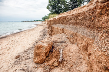
The coastline is one of the fast-changing coastal landforms. Thus, frequent monitoring and accurate detection of coastlines are very important to understanding the coastal dynamics and processes of several coastal features. Geographic Information systems and Remote sensing are technologies that can play an important function in monitoring and managing coastal erosion by offering useful information about changes in the coastal environment. Remote sensing can be used to compare images of coastal areas over time, allowing for the detection of changes in shoreline position and land cover. This can assist in detecting areas facing erosion and realising the magnitude of the changes. Remote sensing technologies, such as Light Detection and Ranging (LiDAR) and satellite-based interferometric synthetic aperture radar (InSAR), can provide high-resolution topographic data. This information is useful for planning erosion control measures, identifying sensitive vulnerable areas, and evaluating changes in coastal elevation. Coastal scientists and managers can develop strategies for monitoring, adapting, and mitigating coastal erosion by combining remote sensing technologies with field measurements. The information obtained from remote sensing data can contribute to more effective and sustainable coastal management practices.

Case Study: Monitoring coastline change in the Kwa-Zulu Natal Tugela River mouth using Coastlines on DE Africa maps.

The KwaZulu-Natal (KZN) coastline is subject to coastal erosion. KZN is located in the southeast of South Africa, with a long shoreline on the Indian Ocean. This coast experiences coastal erosion as a result of storm events and sea levels. Regular erosion occurs during normal spring tide, the results of which are often worsened by a decrease in sediment supply. A regional sand deficiency has been observed on the KZN coast, this can be due to drought, sand mining, dam construction, and misguided coastal development (Oceanographic Research Institute, 2017). Furthermore, protection actions such as breakwaters can obstruct the flow of sand, resulting in sand gathering at beaches to the south of the structure, while beaches to the north continue to erode.

The KZN coastline experienced several coastal erosion events in the year 2006/2007 and between mid-May and November 2011. The 2007 coastal erosion events were caused by high swells and austral winter erosion events. Severe coastal erosion occurred along the KwaZulu-Natal coastline between mid-May and November 2011. The 2011 erosion season was driven by relatively low swells (significant wave heights were between 2 m and 4.5 m) but of long duration. Swell-propagation direction and swell duration played a major role in driving the 2011 erosion event (Alan Smith et al., 2013). Sandy beaches underlain by shallow bedrock and thick sandy beaches were noted to be two erosion hotspot types for this area.

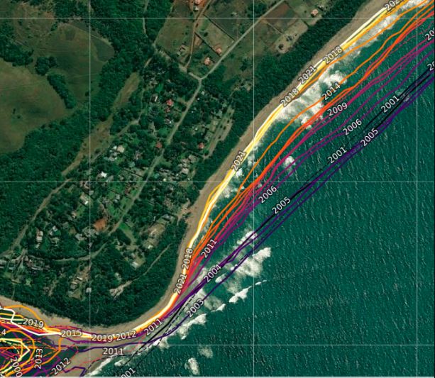
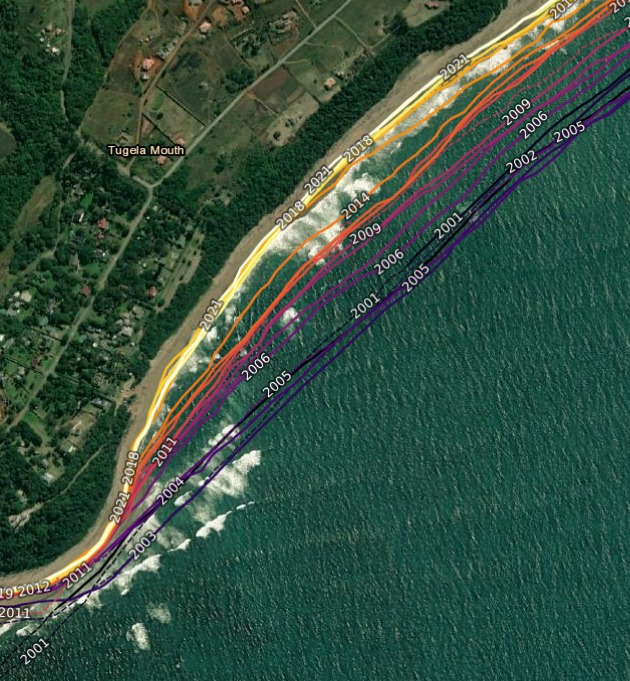
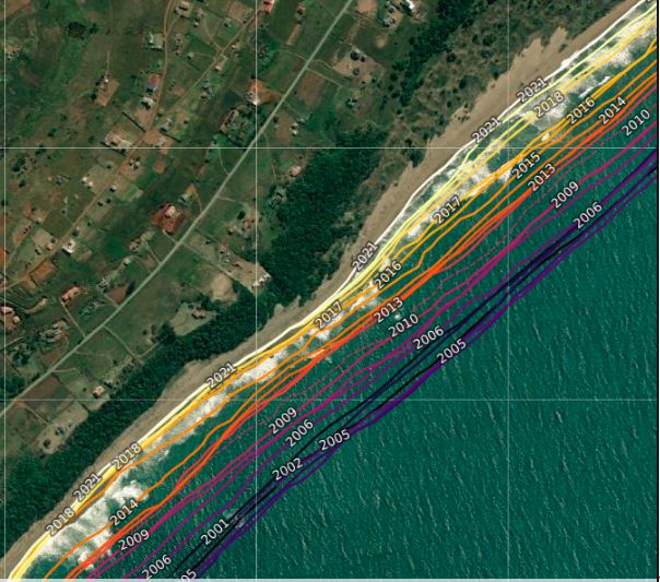
This case study makes use of a remote sensing platform called Digital Earth Africa to monitor coastline changes. The notebook was used to assess trends in coastal expansion and erosion for the coast of Kwa-Zulu Natal Province, near the Tugela River mouth with the coordinates (-29.21,31.5). Digital Earth Africa Coastlines is a continental dataset that consists of annual shorelines and rates of coastal change for the whole African coastline. The product merges satellite data from the Digital Earth Africa program with tidal modeling to map the typical location of the coastline at mean sea level each year. The tool makes it possible to assess trends in coastal expansion and erosion at both the local and continental scales, enabling historical mapping of coastal change patterns to be updated regularly as new data is obtained. This enables current rates of coastal change to be compared with those observed in previous years or decades (DE Africa,2020). The ability to map the positions of the shoreline every year offers an important understanding of whether changes to the coastline are a result of one-time occurrences or a longer-term pattern of steady developments.

The results ( see images below) of the DE Africa coastline indicate that this coastline near Tugela River mouth has retreated by – 14 metres (+-1.5) per year on average since the year 2000. The shoreline in the area of the Tugela River mouth was the most seaward in 2003, and most landward in 2020. Since the year 2000, the median annual position of the shoreline has moved a distance of approximately 257 metres.

Note: Annual shoreline positions represent the median position of the shoreline for each year, corrected to the approximate mean sea level tide. They do not reflect short-term shoreline variability such as changes in shoreline positions between low and high tide, seasonal effects or short-lived influences of individual storms.

Monitoring coastline change in the Kwa-Zulu Natal Tugela River mouth using Coastlines on DE Africa maps showing how coastlines have retreated over the years.

Earth Observation Tools

Digital Earth Africa

Digital Earth Africa offers an operational data infrastructure making current and historical, analysis-ready satellite data freely available and openly accessible for the entire continent. This further enables turning raw data into decision-ready products to inform policy and drive action. DE Africa is made possible by Australian innovation using the Open Data Cube which is internationally recognised as a game-changer for the use of satellite information to address sustainable development challenges. We provide a unique platform that democratizes the capacity to process and analyse satellite data. It tracks changes across Africa in unprecedented detail and will provide data on a vast number of issues, including soil and coastal erosion, agriculture, forest and desert development, water quality, and changes to human settlements. It will also provide an integrating functionality to ensure it complements other existing data.

Data

Reports

National Coastal Climate Change Vulnerability Assessment 2020- Department of forestry fisheries and the environment

Climate change with an expected increase in storm frequency and severity, as well as projected sea level rise and population increase in the coastal zone further exacerbate the expected damage to infrastructure and the vulnerability of coastal population through coastal flooding and erosion. These projections emphasize the importance of climate and global-change-geared adaptation of the coast. However, the work conducted for the development of the National Coastal Management Programme in 2015 points out that there are still significant knowledge gaps related to these factors.

National climate risk and vulnerability (CRV) assessment framework, 2020- Department of forestry fisheries and the environment

In South Africa, there is no standard approach and there is also lack of consensus regarding the appropriate frameworks and best methodologies for assessing vulnerability. This framework, therefore, provides a holistic focus on the full spectrum of adaptation measures, plans and strategies thus constituting a new approach to vulnerability assessments.

Climate risk country profile- World Bank

Climate change is a major risk to good development outcomes, and the World Bank Group is committed to playing an important role in helping countries such as South Africa to integrate climate action into their core development agendas.

Bibliography

  • Alan Smith1 et al. (2013) ‘KwaZulu-Natal coastal erosion events of 2006/2007 and 2011: A predictive tool?’, South African Journal of Science, Volume 109(Number 3).
  • Bishop-Taylor, R., Nanson, R., Sagar, S., Lymburner, L. (2021). Mapping Australia’s dynamic coastline at mean sea level using three decades of Landsat imagery. Remote Sensing of Environment, 267, 112734. Available: https://doi.org/10.1016/j.rse.2021.112734
  • Bishop-Taylor, R., Sagar, S., Lymburner, L., Alam, I., Sixsmith, J. (2019). Sub-pixel waterline extraction: characterising accuracy and sensitivity to indices and spectra. Remote Sensing, 11 (24):2984. Available: https://doi.org/10.3390/rs11242984
  • Beroya-eitner MA. 2016. Ecological vulnerability indicators. Ecol Indic. 60:329–334.
  • Islam, T. and Ryan, J. (2016) ‘Chapter 5 – Hazard Identification—Natural Hazards’, in T. Islam and J. Ryan (eds) Hazard Mitigation in Emergency Management. Butterworth-Heinemann, pp. 129–170. Available at: https://doi.org/10.1016/B978-0-12-420134-7.00005-9.
  • Kabisch N, Korn H, Stadler J, Bonn A. 2017. Making the Case for Sustainable Urban Drainage Systems as a Nature-Based Solution to Urban Flooding: Linkages between S. Bonn NK• HKJS• A, editor. Leipzig, Germany: Springer Open.
  • Morris RL, Konlechner TM, Ghisalberti M, Swearer SE. 2018. From grey to green: Efficacy of eco-engineering solutions for nature-based coastal defence. Glob Chang Biol. 24(5):1827–1842.
  • M. Marchand (Ed.). Concepts and Science for Coastal Erosion Management. Concise report for policy makers. Deltares, Delft. 2010.
  • Oceanographic Research Institute (2017) ‘Coastal issues.Coastal erosion’, Coastal issues.Coastal erosion. Available at: https://www.coastkzn.co.za/themes/coastal-issues/coastal-erosion/
  • Peter R. Teske,Christopher D. McQuaid,P. W. Froneman,P. William Froneman,Nigel P. Barker.2006. Impacts of marine biogeographic boundaries on phylogeographic patterns of three South African estuarine crustaceans. Marine Ecology Progress Series.DOI: 10.3354/meps314283
  • Poole AE, Bradley D, Salazar R, Macdonald DW. 2013. Optimizing agri-environment schemes to improve river health and conservation value. Agric Ecosyst Environ. 181:157–168